
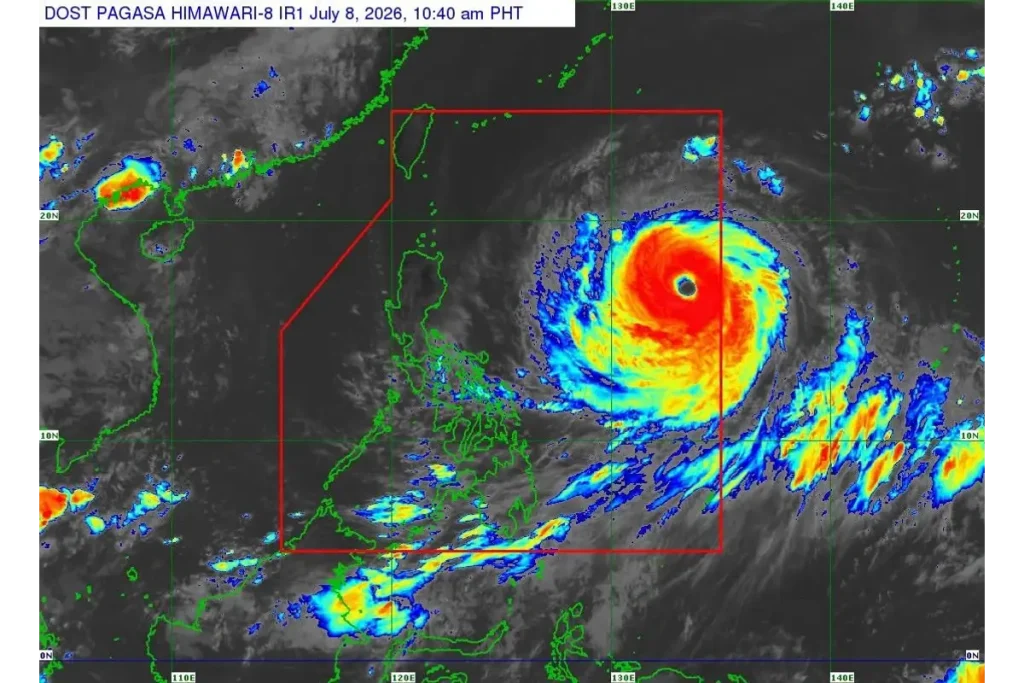
As the powerful Super Typhoon Inday enters the Philippine Area of Responsibility (PAR) on Wednesday, July 8, 2026, state weather bureau PAGASA has placed government agencies on red alert, warning of severe winds and life-threatening storm surges across Northern Luzon. The massive atmospheric disturbance is packing catastrophic winds and is currently threating coastal shipping lanes and remote northern provinces.
1. PAGASA Tracks the Path of Super Typhoon Inday
State weather bureau PAGASA assigned the local name Inday to Super Typhoon Bavi late Tuesday evening as it rapidly approached the country. Spanning a massive wind radius of over 900 kilometers, the storm represents a severe threat to coastal communities.
“The public is advised to continue monitoring official weather updates on the super typhoon as forecasts may still change,” PAGASA weather specialist Chenel Dominguez warned during a press briefing.
Meteorologists note that while the eye of the storm may remain slightly offshore over the Philippine Sea, the outer wind bands are wide enough to severely impact extreme Northern Luzon. Local disaster response units have already initiated localized warning procedures.
2. President Marcos Places Government on Red Alert
Following the storm’s official entry into the Philippine Area of Responsibility, Malacañang issued directives for immediate mobilization. President Ferdinand R. Marcos Jr. has placed all disaster response units and government agencies on full alert.
Disaster councils are currently coordinating preemptive evacuations in flood-prone and landslide-susceptible areas of Cagayan Valley and the Cordillera region. Government resources are being routed to critical zones to minimize casualties and prepare for Super Typhoon Inday’s outer bands.
3. Southwest Monsoon Intensified by Super Typhoon Inday
Even in areas far from the storm’s core, the impact is already being felt. The massive atmospheric pull of the typhoon is significantly strengthening the southwest monsoon, locally known as Habagat.
Heavy, continuous rainfall is expected across the Visayas, Mindanao, and parts of Southern Luzon. Coastal villages are urged to brace for dangerous storm surges heavily affected by the southwest monsoon enhanced by Super Typhoon Inday.
4. Emergency Preparations and Port Closures
As part of the disaster response, the Department of Social Welfare and Development (DSWD) has pre-positioned thousands of family food packs in Batanes and Cagayan. Additionally, maritime authorities have acted quickly to ensure safety at sea.
The Philippine Ports Authority (PPA) cancelled numerous vessel trips in major ports, including Batangas, Mindoro, and Zamboanga, due to rough sea conditions. Travel has been suspended for all types of vessels along the eastern and northern seaboards of Luzon to prevent maritime casualties.
5. Storm Intensity and Wind Signal Metrics
To provide a clearer picture of the storm’s current strength and track, meteorological agencies have released vital structural data. The latest meteorological data regarding Super Typhoon Inday is detailed below:
| Metric | Current Measurement | Expected Impact Zone | Alert Level |
|---|---|---|---|
| Maximum Sustained Winds | 195 km/h near the center | Extreme Northern Luzon / Philippine Sea | Super Typhoon Class |
| Peak Gustiness | Up to 230 km/h | Batanes, Babuyan Islands, Cagayan | Severe Threat |
| Wind Radius Extent | 900 km from the center | Luzon, Visayas, and parts of Mindanao | Monsoon Enhancement |